You may order my book online
from Cedar Fort Publishing
at a 15% discount.
Here is a link directly to My
book at their web site. Click
LOOK INSIDE to view
the first few pages of my book including the book's cover and first chapter.
(Cedar Fort Publishing now has a new website and a new look.
Here is a link to their new site: Cedar Fort.)
A few inaccuracies have been found in my book.
Click on the addendum to view the corrections.
Here are a few locations where my book might be purchased:
|
Barnes & Noble
330 E. 1300 S. Orem, Utah 801-229-1611 |
BYU Bookstore
Provo, Utah 801-422-3584 |
Cedar Fort Publishing
2373 W. 700 S. Springville, Utah 801-489-4084 |
|
Confetti Antiques & Books |
Eagles Landing Scipio Chevron
810 N. 800 W. Scipio, Utah 435-758-2345 |
Garden Gate Bookstore
45 E. Main Vernal, Utah 435-789-2141 |
|
Inspirations
1431 E. Hwy. 40 Roosevelt, Utah 435-722-2160 |
Prospector Supply
153 W. 400 N. Orem, Utah 801-224-3493 |
Seagull Book
at various locations in UT, CA, AZ & ID |
|
Simmons Furniture & Hardware
1 N. Main St. Manti, Utah 435-835-3151 |
Spanish Trails Prospecting
45 E. 200 N. Spanish Fork, Utah 801-798-1738 |
Old Pioneer Press
97 W. Main St. Santaquin, Utah 84655 |
Here is a little insight and background into my book:
Since 1979, when these legends first came to my attention, I have amassed
a fair amount of information and
documentation about Utah's rich heritage. I believe it is my privilege and
obligation to share some of that knowledge with you.
It's difficult to place very much information on a web site without lots of
server space and slowing down the site.
Therefore for the past three years I have been compiling maps, documents and
other germane information.
I hope you find my book both entertaining, and informative. Here's a peek.
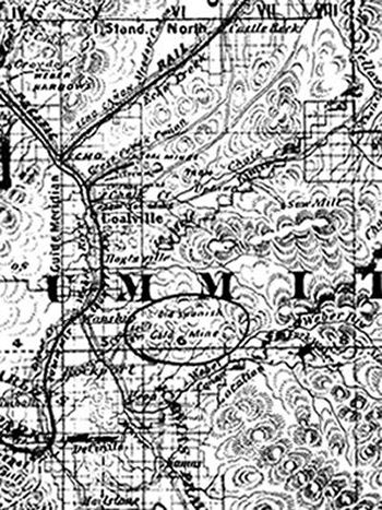 |
The Spanish were in Utah long before the Mormon pioneers arrived.
This 1878 Froiseth's mineral map of Utah shows the general
location of an "Old Spanish Gold Mine".
Several maps are in my new book including maps showing "oro" (gold)
locations.
Most of these maps have never been available to the public before.
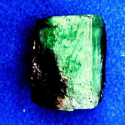
I reveal a little known fact that emeralds have also been recovered in this
beautiful state.
Included are pictures of the largest known specimen of nearly 1 inch in length.
I give the GPS coordinates to its discovery location which is now under claim.
 |
There has been an overwhelming demand for the treasure tales.
Nearly everyone likes an intriguing story about lost treasure.
Many stories, both short and long, are in my book including:
Cump Murray's Rich Mine, Payson Canyon's Cursed Mine,
The Crescent Mine near Tworoose Pass,
Sugar loaf's Golden Treasure, and many more.
Examples of many symbols are in the book including crosses,
cat faces and others.
Important information for the searcher is given about the Sacred Mine of
the Ute's.
Even though there could easily be more than one sacred mine the one described
in my book would be one worth looking for.
|
Many people believe the Sacred Mine or Carre-Shin-ob is in the White Rocks River area. One entire chapter, including a map, will reinforce this idea.
|
Legend states that the LDS Church once obtained gold
from a rich mine under the watchful eye of Chief Walker.
This gold is alleged to have been used to plate temple
objects as well as the minting of Mormon gold coins.
|
belonged to the LDS Church. I have taken this opportunity to describe this map in some detail. I believe it is a sacred location, therefore, I will hold a few details in reserve. Even so the amount of information given will most likely catch your interest. |
Following the Legends book Addendum, Updated 10-4-07
1. A few of the references are inaccurate. To solve the problem
until the 2nd printing please
do the following: Each time a page is referenced subtract 2 from it and the
page number will
be accurate. I.e. On page 60 a reference is made to page 57 but instead it
should be 55.
The problem is consistent. The mistakes are on pages 60, 84, 89, 130, 142,
161, and 162.
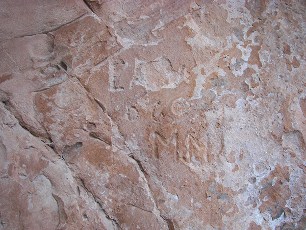
2. It has come to my attention that a photograph in my book
may have been altered before it was
given to me. The picture in question is on page 217. We refer to it as the
CBR rock and it's
located on Native American property. It was my privilege to see this rock
for myself with
the help of two very pleasant Native American friends on September 8, 2007.
I took a
picture of the rock for myself, at that time, and this is how it looked:
 |
3. On page 100 of my book a reference was made to Kerry's stepbrother but
instead
it should have read foster-brother. I'm sorry for that mistake Kerry.
4. On page 140 of my book there is a map which was given to me by Ed Twitchell
and he probably obtained it from Gale Rhoades. I may have implied that Kerry
and Gale altered this map and reversed it from right to left. After the printing
of my book I learned that the Spanish also altered maps in that manner. Even
though Lisa Boren stated in a public forum that her husband Kerry and Gale
Rhoades altered many maps by "removing certain symbols or landmarks,
reversing images, and so forth," this map may not be one of those she
was
referring to. I apologize if my assumption was inaccurate.
It has been my goal from the beginning to keep my book as accurate as possible.
Hopefully this public medium will keep us on track until the next printing.
Sorry for any inconvenience these errors may have caused.
Sincerely, Dale Bascom
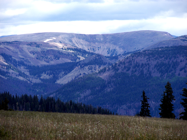 |
This picture offers greater clarity to the idea of pyramids in Utah.
(The image in my book on page 154 leaves a little bit to be desired.)
Notice in this picture of upper Cabin Creek how distinct the pyramid shaped
hill is.
There is more evidence that gives credence to this hill being an ancient repository,
like a pyramid, but I'm not at liberty to explain.
Last update 8/11/11